Share this Post
LET’S GET OUT FOR A WALK IN TOKYO’S HINTERLANDS, WESTERN TOKYO, AKA THE TAMA AREA OR THE ‘BED TOWNS’
The area of West Tokyo was not traditionally part of old Edo, but was incorporated into the new Metropolis of Tokyo during WWII (1943 actually). This area has its own cities, towns, and villages. There are verdant rivers, a lot of apartment buildings, and lonely mountain areas. Of course there is the World Heritage Site of Takao San, but there are several mountain areas to explore with my personal favorite being in the northwest section of Tama city called Mt. Mitake. Mitake is basically the shinto version of Mt. Takao, but not a World Heritage Site. This region is extremely popular with Japanese trying to get out of urban Tokyo and relax somewhere in nature, especially the Tama river valley at the flowing past Mt. Takao. But there are trails crisscrossing these mountain and going into the neighboring prefectures of Kanagawa, Yamanashi, and Saitama. Have fun taking several of the roads less travelled with some of these West Tokyo walking courses. Enjoy! If you have got cabin fever from all this Coronavirus avoidance that is going on or you use want to go for a short walk around town then this post has you covered… for West Tokyo. Here is the basic information to go outdoors and roam the more rural sections of the city while still basically doing Social Distancing. Just remember to practice the three Cs: No Crowds, No Closed Spaces, and No Close Conversations. And don’t to forget to bring along a medical mask for good measure. Let’s go walking!THERE ARE THREE CHOICES For exploring West Tokyo
CHOICE ONE – PAN-TOKYO WALKING COURSES
[dropcapT[/dropcap]hese courses are all over Tokyo and take in the natural and cultural spots of the city. This system of walking courses was created by the metropolis of Tokyo twenty or more years ago, before it was felt to have a web presence. Even the guide materials have run out a long time ago. There are markers all around with huge beginning and ending placards talking about the courses and maps. Here and there are descriptions about the place and its history. This course system goes between and connects the different wards. It is pretty old and well-established. However, it is all in Japanese and the current government information, even the most up to date information on the internet, seems a little minimalistic. So if your Japanese is fluent and you don’t mind getting a little lost from time to time, but are confident you can find your way back without much trouble, then this is the best option. But if your Japanese is not so great, then be ready to fire up your smartphone’s Google Translate, because you are in for the best slow moving walking adventure that Tokyo has to offer.CHOICE TWO – KANTO FUREAI NO MICHI : THE CAPITAL TRAIL SYSTEM
These courses are all over Kanto; including Tokyo, Saitama, CHIBA, Kanagawa, Yamanashi, and Tochigi. It meanders through the back countryside of the different prefectures and takes in the natural and cultural spots. This system of walking courses was created by the prefectures twenty or more years ago, before it was felt to have a web presence. Even the guide materials have run out a long time ago. There are markers all around with huge beginning and ending placards talking about the courses and maps. Here and there are descriptions about the place and its history. This course system goes between and connects the different prefectures of Kanto and maybe some beyond. It is pretty old and well-established. However it is in the countryside so it can be deemed unnecessary travel a bit beyond what is necessary for basic exercise. But if you live near one of these then definitely check it out! However, it is all in Japanese and the current government information, even the most up to date information on the internet, seems a little minimalistic. So if your Japanese is fluent and you don’t mind getting a little lost from time to time, but are confident you can find your way back without much trouble, then this is pretty good. But if your Japanese is not so great, then be ready to fire up your smartphone’s Google Translate and Google Maps, because you are in for the best slow moving walking adventure that Kanto has to offer.OFFICIAL ALL JAPAN LONG DISTANCE NATURE TRAIL SYSTEM COURTESY OF THE MINISTRY OF THE ENVIRONMENT
OFFICIAL KANTO FUREAI NO MICHI TRAIL SYSTEM COURTESY OF THE MINISTRY OF THE ENVIRONMENT
CHOICE THREE – CITY, TOWN OR VILLAGE SPECIFIC WALKING COURSES
The Cities of Western Tokyo
These courses are a great way to get to know the history, nature, and culture of specific cities in West Tokyo. And it seems that just about every city has their own fairly well maintained web sites giving a lot of information about their courses as well as a huge pan-Tokyo site in multiple foreign languages including English. So wherever you are in Tokyo, check out your local ward’s or city’s Walking Course site and you should find something interesting nearby. Get ready to find something interesting in areas you hadn’t thought to look at before or something new about an area that you have been to many times.A word to the wise. The cities of West Tokyo cater heavily to domestic tourism and don’t seem to have as much resources or know-how as the Special Wards of Tokyo. So their webistes for hiking and walking courses have a strong tendency to be Japanese only links to their city’s pdf pamphlets with the necessary maps included there in. You might want to download these resources at home over your wifi instead of using your smartphone’s mobile bandwidth, because some of these files are quite large! So, just be warned about that. These courses are usually part of the western Tokyo cities’ attempts to market themselves for outside Japanese visitors, so English is sometimes available, but usually not. It just depends on the city. Just be ready to fire up your smartphone’s Google Translate before you go. The city hiking courses do not always cross into other cities or wards. So get ready to get to know one at a time, really, really well! So if you live in West Tokyo, or nearby, these great resources full of information that you can’t find anywhere else.
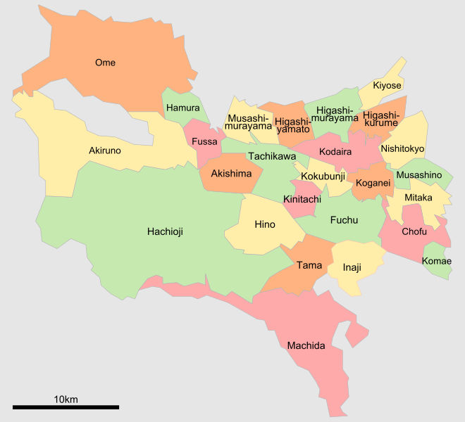
Map of Tokyo’s Western Tama Wards Thanks to Tokyoship / Public domain
Akiruno city, Tokyo, Walking Map Linkhttps://www.city.akiruno.tokyo.jp/0000003018.html
Nishi-Tama District: West West Tokyo Too Mountainous For Urbanization
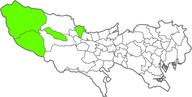
Map of Tokyo’s Nishi-Tama Mountain Area Thanks to Tokyoship / CC0
Hinode town, Tokyo, Walking Map Linkhttps://www.hinodekanko.jp/ハイキングコース/
Related Articles on Trekking in Tokyo and Kanto
Tokyo Promenade of History and Culture
August 27, 2024Course 23 – Takao Hachioji Walking Course | 高尾八王子コース
August 16, 2024Course 22 – Fuchū Kokubunji Walking Course | 府中国分寺コース
August 14, 2024Course 21 – Inokashira Jindaiji Walking Course | 井の頭深大寺コース
August 7, 2024Image thanks to
If these articles have helped you in any way please feel free to click here to help support us by making a donation on PayPal
Buy me a coffee, or two, or three ;-D

